Trip Report: Harper's Ferry (WV, MD, VA)
Map of the hike (MapQuest with local modifications)
Three-state Hike, 5-22-97
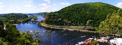
 An unusual hike with an unlikely group of people. Myself, Jill Callahan, Andrew Zirm. We started in the historic town of Harper's Ferry, WV at the confluence of the Potomac and Shenandoah rivers. Crossing a railroad bridge into Maryland, we hiked along a level, tree-lined path between the old C&O Canal and the wide, shallow expanse of the Potomac.
This peaceful interlude was soon interupted by a harrowing crossing of the river on the side of the highway 340 bridge and a walk along the side of the road into Virginia. After perhaps a quarter of a mile, solitude was regained as we left the road and climbed the steep slope of Loudon Heights on the trail of the same name.
An unusual hike with an unlikely group of people. Myself, Jill Callahan, Andrew Zirm. We started in the historic town of Harper's Ferry, WV at the confluence of the Potomac and Shenandoah rivers. Crossing a railroad bridge into Maryland, we hiked along a level, tree-lined path between the old C&O Canal and the wide, shallow expanse of the Potomac.
This peaceful interlude was soon interupted by a harrowing crossing of the river on the side of the highway 340 bridge and a walk along the side of the road into Virginia. After perhaps a quarter of a mile, solitude was regained as we left the road and climbed the steep slope of Loudon Heights on the trail of the same name.After a brief, enjoyable climb, we reached the overlook at Slick Rocks with nice views of the river and town of Harper's Ferry. The trail continued to climb through pleasant hardwoods past an excellent boulder until meeting with the Appalachian trail. Descending, we quickly came to the third and final bridge of the trip bringing us back into West Virginia, this time across the Shenandoah. The trail passes several historic spots including the lovely hilltop Harper Cemetery established in the 1700's and Jefferson's Rock, a large rock where supposedly Thomas Jefferson stood and surveyed the land. The town of Harper's Ferry is lovely with lots of things to do if you're a history buff.
Maryland Heights Hike, 2-28-98
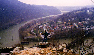 On a marginal day, Courtenay and I set out across the railroad bridge and hiked Maryland Heights. This under-three-mile hike is easy and provides some really exceptional views of the town and the surrounding hills. After turning right from the C&O canal path, a pleasent hike through woods on an ascending jeep road brings you to the height of land above the river. Supposedly an old naval battery exists here, but we saw no signs of it. A longer loop trail departs to the left and can be followed to the actual summit and several other sets of ruins.
We elected instead, since time was pressing, to continue on to the bluffs. After a few switch-backs on a lovely single-track trail, we were dropped onto the top of a series of crags with sheer 100' drop-offs and fabulous views of the two rivers and the town in between. The fog was starting to come in and everything looked very historical. We continued down a steep trail depositing us on the road on the land side of the canal. Getting from their back to the canal path was quite an adventure.
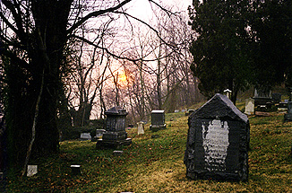
After the hike we explored the mizzling town and crept up the the really cool graveyard that dates from the town's founding at the top of the hill. Being the kind of dank day made for graveyards, we slouched around reading gravemarkers and enjoying several times our USRDA of ambiance. The rain stopped and the setting sun started to peak out through the baren trees.
 The Wilderness Journal |  Neithernor |